
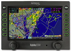
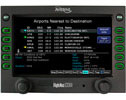
Avidyne EX500 Multi-Funtion Display
 |
EX500 MFD |
||
- Overview
- Functionality
- DataLink
- Upgrade an EX500
- CMax
- Specifications
- EX600 Video
EX500
Avidyne is committed to designing products that improve situational awareness and safety. And just as important, Avidyne is uniquely focused on developing products that are easy to use. With the FlightMax EX500, Avidyne offers the most pilot-friendly multifunction displays available for general aviation.

 |
 |
 |
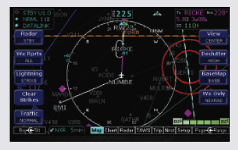
The EX500’s user interface dramatically improves your ability to access and display critical flight data. This design philosophy keeps operation simple and consistent by allowing you to select and display what you need on a single easy-to interpret integrated moving map. As a radar display replacement, the EX500 provides easy access to radar modes, tilt control, and bearing adjust.
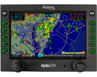
With the EX500’s "map-centric" operation, you can display a moving map of your flight plan along with radar and datalink weather. And special-use airspace. And traffic. And terrain. And lightning. All without ever leaving the map page. It's the only MFD available that provides the complete picture. And it's the easiest to use.
The EX500 keeps you connected with the complete weather picture, allowing you to view datalink graphical weather information, seamlessly integrated with your flight plan moving map, lightning, traffic, and terrain display. All special-use and class airspaces are color-keyed for added clarity, and can be displayed at the same time as NEXRAD or weather radar for a more complete picture. Comprehensive Jeppesen NavData™ and an expansive North American obstacle database provide an unparalleled view of your flight environment.
Full overlay capability allows you to add or remove traffic, lightning, and radar, with 180-degree forward view and 360-degree center view maps.
The Easiest To Use
The FlightMax EX500’s user interface dramatically improves your ability to access and display critical flight data. This design philosophy keeps operation simple and consistent by allowing you to select and display what you need on a single easy-to interpret integrated moving map. As a radar replacement, the FlightMax EX500 provides easy access to radar modes, tilt control, and bearing adjust. With the FlightMax EX500’s “map-centric” operation, you can display a moving map of your flightplan along with radar and datalink weather. And special-use airspace. And traffic. And terrain. And lightning. Without ever leaving the map page. It’s the only display that provides the complete picture and it’s the easiest to use.
The EX500/EX5000 is Avidyne’s third generation MFD platform, incorporating everything we have learned since developing general aviation’s first stand-alone retrofit MFD in the mid- 90s, the Flight Situation Display, and the industry’s first “full overlay-capable” MFD, the FlightMax 750-Series.
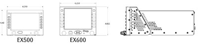
The EX500 fits in a standard 6.25-inch ‘mark-width’ radio stack. The 4-knob version of the EX500 is designed to replace existing CRT-based radar indicators for any of 19 different radar systems. A 2-knob version is also available for use in single-engine piston aircraft that do not carry an on-board weather radar. The extra knobs on the 4-knob system are dedicated to radar BRG and TILT control, making in much easier to operate than competing radar-capable displays. All other functions are identical between the two.
NEXRAD Vs. Airborne RADAR

![]() Click here to download an article written by Mark Hangen explaining how the strategic benefits of datalink RADAR complement the tactical benefits of on-board radar.
Click here to download an article written by Mark Hangen explaining how the strategic benefits of datalink RADAR complement the tactical benefits of on-board radar.
Most Radar Interfaces
EX500 radar interfaces include the Bendix/King® RDR2000/2100 and Bendix RDS8X-series digital radar systems, including Vertical Profile™ versions. In addition, the EX500 supports the unstabilized Bendix RDR130/150/160 systems and the fully-stabilized RDR1100/1200/1300 systems. If you are replacing a CRT that is monochromatic, the EX500 will convert it to color. Rounding out the list, the EX500 can also replace the CRT display of Rockwell-Collins® WXR250/270/300-series radars.
EX500 Functionality
Curved Paths
When flying GPS approaches, the EX500’s large display clearly shows curved flight path segments when provided by the GPS, including DME arcs, Holding Patterns and Procedure Turns, overlaid with traffic, terrain, weather, airports and runway diagrams. And with Avidyne’s CMax™ Electronic Charts, the EX500 really takes the guess work out of shooting instrument approaches.
Ultra-Bright, High-Resolution Display
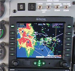
The EX500 features our industry-leading, high- resolution, active-matrix liquid-crystal display (AMLCD), providing you with the brightest, most versatile big-screen moving map available. With nearly three times as many pixels as previous-generation displays, and an incredibly wide viewing angle, the EX500 provides clear and concise navigation and weather information over an exceptional color-contoured terrain and water base map.
Trip Page
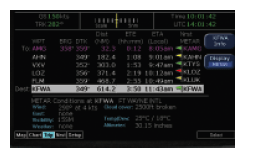 EX500The EX500's versatile Trip Page provides information about your route of flight including a list of all remaining waypoints in the active flightplan, with distances and times for each leg. Graphical METARs for all reporting airports are also listed, which can help you in determining an alternate airport in the event of inclement weather or an emergency situation. Textual METARs are also available for each reporting airport. The EX500 translates the METAR abbreviations into plain English for easy interpretation.
Terrain and Obstacles
 EX500With its complete terrain and water base map, and a North American database containing towers and other obstacles greater than 200’ AGL, the EX500 provides a clear presentation of terrain hazards. Obstacles can be displayed with MSL altitude labels, and Avidyne’s exclusive terrain scale shows the altitude of the highest terrain and obstacle height in the displayed area. The “nearest obstacle” feature makes it easy to determine the height and proximity of nearby towers as you descend into any unfamiliar areas. The EX500 also interfaces with the popular EGPWS/TAWS sensors for added safety, making it the most versatile multi-function display available.
TFRs
Temporary Flight Restriction (TFR) areas are updated via datalink to provide the most up-to-date information about your flight environment. Having the complete picture gives you the ability to avoid hazardous weather conditions and stay clear of restricted airspaces, saving you time and fuel.
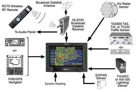
EX500 DataLink
Satellite Datalink Weather and Entertainment
Avidyne leads the industry in datalink-capable multifunction displays and the EX500 and EX5000 MFDs provide the most advanced, and easiest-to-use datalink systems you can get.
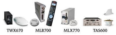
Interfacing the MFD with Avidyne’s MLB700 Broadcast Datalink Receiver gives pilots comprehensive, graphical information about weather conditions all across the Continental United States (CONUS).
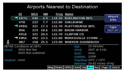 The NRST Page shows graphical and textual METARs at the destination and surrounding airports, making it easy to monitor weather ahead and select an alternate when needed.
Using the industry-leading WSI InFlight® Weather Service via the SIRIUS® Satellite Network, the EX500 MFD displays critical, real-time information for pilots, including WSI’s exclusive high-resolution NOWrad® radar mosaic, overlaid right on the moving map. The EX500 also displays Storm Track Vectors, Hail Warnings, AIRMETs, SIGMETs, graphical and textual METARs, TAFs, Temperatures and Winds Aloft, TFRs, and Lightning from the United States Precision Lightning Network.
Lightning

WSI InFlight® provides access to lightning data from the United States Precision Lightning Network while operating over the continental United States (CONUS). This provides aircraft owners with the unique capability to configure an aircraft with ground-based lightning detection, airborne lightning detection, or a combination of ground and airborne lightning detection ability.
Graphical METARs

METAR is an Acronym for METeorological Aerodrome Report. It is the primary observation code used in the United States for reporting surface meteorological data. METAR reports include wind, visibility, runway visual range, present weather, sky condition, temperature, dew point, and altimeter setting. In the U.S., METAR reports are taken once an hour between 50 minutes past the hour and the top of the (next) hour. METARs are displayed as a “colored flag” on each reporting METAR station on the EX500 MFD moving map.
AIRMETs and SIGMETs

AIRMET and SIGMET boundaries are also displayed graphically on the map page. It was not uncommon for a pilot to fly into a active AIRMET or SIGMET simply because the boundaries where difficult to define, but with the EX500, pilots can quickly and easily recognize the boundary lines for each active AIRMET or SIGMENT and avoid potentially dangerous areas of weather.
TFRs
All Special-Use and Class Airspace boundaries are clearly depicted on the map, along with available Temporary Flight Restrictions (TFRs) which are updated as part of WSI InFlight. The EX500’s high-resolution display allows you to easily see and remain clear of restricted airspaces.

The EX500 MFD Map page with broadcast datalink weather, integrated onboard lightning detection and integration onboard color weather radar capability offers pilots a level of weather and airspace situational awareness that has never before been available in general aviation aircraft.

SIRIUS Satellite Radio
With the MLB700, you also have access to over 130 channels of digital-quality music, sports, news, and talk radio, right through your aircraft's audio system.
Audio content can be selected from anywhere in the aircraft using the RC70 wireless RF remote control.
Product Comparison
Click here to see how the FlightMax EX500 compares with the MX20.
Upgrade your existing EX500 to EX600
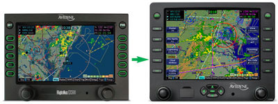
EX500 owners now have the option to upgrade to the new EX600.
Why Upgrade to EX600?
- Larger (5.8-inch diagonal) Transflective Display
- Better readability in sunlight & in low light
- Full 640x480 VGA Display
- 40% More Pixels
- 25% larger viewing area
- New Bezel and Glass
- Dedicated directional Map Panning Keys
- Makes it easy to move to anywhere on the map
- Especially useful for viewing the weather at your destination
- Exclusive QuickPan™ function
- Easily toggles between panned-to position and present position
- Ideal for monitoring weather at destination throughout your flight
- Upgrade and trade-in programs available
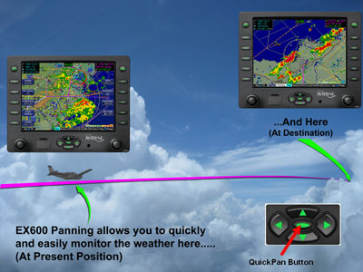
The biggest safety and utility enhancement of the EX600 is its new QuickPan function which makes it easy to view weather at your present position and at your destination with a single button push.
Avidyne’s FlySafe discounts make upgrading to the EX600 a great time to consider additional safety sensors including Datalink Weather, Color Lighting and Traffic Advisory Systems.
While all electrical wiring is identical, the EX600 is a little more than half an inch taller than the EX500 and thus will require some minimal panel work and changing of the mounting tray in order to accommodate the upgrade.
![]() Click here to learn more about the EX500 to EX600 upgrade program.
Click here to learn more about the EX500 to EX600 upgrade program.
EX500 CMax™
"I was glad to have Jeppesen charts on the Avidyne display to show me exactly where I was on the airport." - J. Mac McClellan - FLYING Sept. 2006 and Avidyne's website
CMax™ Approach Charts allow EX500 and EX5000 customers to view approach charts and airport diagrams along with their aircraft’s position and flight plan for improved situational awareness during the most critical phases of flight.
Cmax is now standard on all new EX500 and EX5000 Multi-Function Displays.

CMax™ Approach Charts, Avidyne’s innovative implementation of this electronic chart capability, displays approach charts and airport diagrams with an overlay of the pilot’s flight plan and present position. CMax provides on-demand access to the worldwide library of JeppView electronic charts and airport diagrams and dramatically improves the pilot's ability to manage cumbersome paper charts.
At startup, the departure airport chart is automatically displayed for ease of orientation, which is especially valuable when taxiing at unfamiliar fields.

The destination airport's list of available approaches is automatically loaded at the time your flight plan is entered, and can be viewed easily using the Auto-fill capability, and the pilot can easily select and view any approach chart for any airport in the database.
CMax™ automatically switches to the destination airport diagram when ground speed drops below 40kts.

CMax™ uses Jeppesen’s JeppView Electronic Airway Manual chart service to reduce the amount of paper required on the flight decks of Avidyne-equipped aircraft. In addition, CMax makes managing and accessing flight critical information more efficient, while eliminating the need for pilots to file traditional revision updates in their Airway Manuals. Jeppesen will send Avidyne customers periodic CD-ROM updates which are loaded onto a personal computer to display and print charts while on the ground, and transferred through the FlightMax dataloader for updates in the airplane.

CMax improves safety and it’s easy to use. Easily load approach charts for your destination using the “auto fill” button, or easily browse and select charts for any airport in the database. CMax shows aircraft position and flight plan right on the approach chart making it much easier to visualize your location throughout the approach. Critical obstacles and terrain are displayed for added safety. As the aircraft ground speed drops below 40kts, CMax automatically switches the display from the approach procedure chart to the airport diagram.
CMax improves surface navigation. CMax airport diagrams include 6,004 airports, 5,695 of which are geo-referenced (we can show aircraft position during taxi). 1,998 are U.S. locations.CMax’s detailed airport diagrams show runways and taxi ways, which is especially useful when operating on unfamiliar airports. CMax™ eliminates the need for “progressive taxi instructions,” and makes it easier to find a particular FBO or parking area.
CMax improves incursion awareness. CMax shows “Runway Incursion Hotspots.” These are areas on certain airports designated by the FAA where ground control may have limited visibility or where there is high traffic flow or other known history of incursion activity.
CMax improves chart management. CMax makes managing and accessing flight critical information more efficient, while eliminating the need to file traditional revision updates in Airway Manuals. Jeppesen sends Avidyne customers periodic CD-ROM updates which are loaded onto a personal computer to display and print charts while on the ground, and transferred through the FlightMax dataloader for updates in the airplane.
EX500 Specifications
| Size | Height | Width | Depth | Weight |
|---|---|---|---|---|
| EX500 MFD | 4.35" | 6.25" | 10.75" | 7.2lbs (3.24kg) |
TSO Compliance
| TSO-C63c | Airborne Weather Radar |
| TSO-C110a | Airborne Passive Thunderstorm Detection |
| TSO-C113 | Airborne Multipurpose Electronic Display |
| TSO-C118 | Traffic Alert & Collision Avoidance (TCAS) |
| TSO-C147 | Traffic Advisory System (TAS) |
| TSO-C157 | Flight Information Systems-Broadcast (FIS-B) |
Displays:
5.5” Diagonal
616×350 pixels
65,535 colors
Ultrabright sunlight readable
Extra-wide viewing angle
System Power:
Max 5.0A @ 28VDC
Environmental:
DO 160D
To 50,000 ft.
-20°C to +55°C Operating
+70°C Short TermExtra
Cooling:
Internal forced air cooling provided
Warranty:
2 Years parts and labor included
Extended warranty service available
The FlightMax EX500 presents navigation, radar, datalink weather, lightning, traffic, and terrain data in an easy-to-interpret format, dramatically improving situational awareness and enhancing safety through all phases of flight.