Garmin GPSMAP 196 Portable GPS
 |
|||
| Part Number: | 010-00301-00
|
||
| Suggested Retail Price: | $ 595.00 | ||
| Our Price: | $ 549.00 | ||
Premier Avionics is an Garmin GTN650 and G600 Demo Dealer
- Overview
- Specifications
- In the Box
- Image
The GPSMAP 196 is a powerful aviation portable that acts like a panel but goes from cockpit to land to water without missing a beat. With its crisp, grayscale screen, the 196 is an affordable introduction to Garmin's portable aviation products.
Enhance Situational Awareness
The WAAS-capable GPSMAP 196 has detailed map graphics, HSI steering guidance, Jeppesen® database and all the other pilot-friendly features you’ve come to expect from Garmin. Steering guidance is clearly presented through a graphic HSI with VNAV indicator offering a full range of horizontal and vertical awareness. Extended runway centerlines help orient pilots to the runway. The 196 even supports a comprehensive U.S. database of obstacles (upgradeable via the Internet) to help you see and avoid high-rise structural hazards in the vicinity of your flight path.
View Images in Sharp Detail
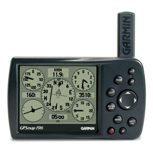
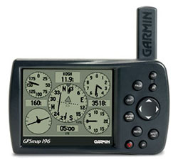
GPSMAP 196 features a 320 x 240 pixel, 12-level grayscale display with exceptional resolution and contrast. This display with backlighting showcases crisp graphics which redraw with incredible speed thanks to a fast processor.
Automate Your Logbook
A built-in logbook tracks your flying hours and automatically records departure and arrival locations. When used with Garmin's free logbook software FlightBook, this feature simplifies record keeping. Flightbook software allows you to create, manage, analyze, save and print flight data from GPSMAP 196's logbook.
Navigate by Air, Land or Sea
Simply press a button to switch GPSMAP 196 to automotive or marine mode. The 196 comes with a built-in routable basemap. Add optional MapSource® detailed street maps for street navigation. Or, for a great day on the water, customize the waterproof 196 with optional marine cartography. Easily add detailed maps with plug and play Garmin data cards.
GPSMAP 196: Go from plane to boat to automobile without missing a beat.
What's in the Box:
- One basemap of Americas Autoroute:
- Free Jeppesen® update certificate
- Yoke mount
- Automotive mount
- Vehicle power cable
- Low-profile remote GPS antenna
- PC interface cable
- Owner's manual
- Quick reference guide
The Garmin GPSMAP 196