Garmin GTN 725 Com/GPS
 |
|||
| Part Number: | 010-00819-50 | ||
Premier Avionics is a
Garmin GTN750, GTN650 and G600/G500 Demo Dealer
- Overview
- Features
- Specifications
- In the Box
- Accessories
- Comparison
- Image
- GTN Video
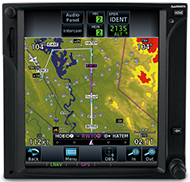
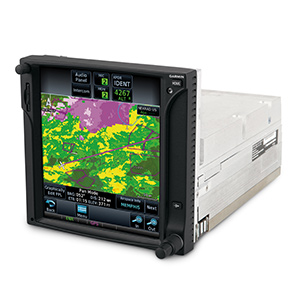
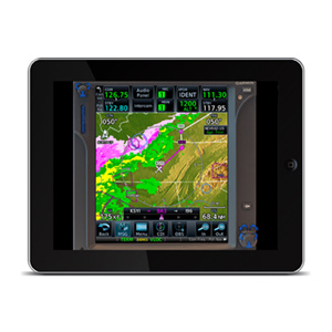
GTN 725 has a 6.9-in. (diagonal) display, intuitive touchscreen interface and wide range of multifunction display capabilities. It puts high-resolution terrain mapping, graphical flight planning, charting, traffic display and multiple weather options right at your fingertips.
Touch & Go
With GTN 725’s touchscreen interface, you’re rarely more than 2 taps away from the system’s primary functions. Enter waypoint data on the high-resolution TFT display and swipe your finger across it to pan the map screen. Built-in gripping points on the bezel and lower edge of the display help you stabilize your fingers while using the touchscreen in-flight. Not keen on touchscreen data entry? GTN 725 also has traditional concentric knobs. And, with a GNS 430W/530W, your active flight plan automatically crossfills from the GTN to the GNS. You can also manually crossfill waypoints.
Navigate with Ease
Edit your entire route on the map screen and easily enter new waypoints or modify existing ones. The system even lets you load Victor and jet airways. Grab any leg of your flight plan route and move it to accommodate a deviation or ATC amendment to your flight plan with the "rubber band" feature. Enter your most recently visited or nearest airports as waypoints and “Direct To” destinations. Built-in Garmin U.S. FliteCharts™ or optional Jeppesen®-style geo-referenced ChartView™ provide geo-referenced approach plates and procedures.
Execute Precision Approaches
The SBAS/WAAS-certified, 15-channel GPS receiver generates 5 position updates per second, letting you fly GPS-guided LPV glidepath instrument approaches down to as low as 200 feet. In addition, precise course deviation and roll steering outputs can be coupled to select autopilots so that IFR flight procedures may be flown automatically. This includes all ARINC 424 leg types, except RF legs. For example, when coupled with a G500/G600 Flight Display, the aircraft can fly fully coupled missed approaches, including heading legs.
See More than Ever Before
Packed full of multifunction display capabilities, GTN 725 brings enhanced situational awareness to your cockpit. High-resolution terrain mapping — including topography features, cities, airports, terminal areas, SUAs and optional Class B TAWS alerting — help you find your way around airspace safely. Smart Airspace™ automatically highlights airspace close to your current altitude and de-emphasizes airspace away from the current altitude. On the ground, built-in Garmin SafeTaxi® airport diagrams show you geo-referenced runways, taxiways, FBOs and hangars available in either the U.S., Europe or Canada.
Add Traffic & Weather
The dual-link GDL® 88 allows GTN 650 to display up to 60 ADS-B traffic targets. TargetTrend™ relative motion technology gives you a faster, more intuitive way to judge the direction and closure rate of intruding targets in relation to your aircraft’s position. And unique SURF technology supports the display of ADS-B-equipped surface targets on Garmin SafeTaxi® airport diagrams — including taxiing aircraft and ground vehicles. GDL 88 can also receive the FAA’s subscription-free FIS-B weather broadcasts that include graphical NEXRAD radar information, as well as NOTAMs, METARs and TAFs. GTN provides GDL 88 with the WAAS position source required for ADS-B, so a WAAS version of GDL 88 is not required. Add a Garmin Traffic System to compliment GDL 88 for the best possible traffic coverage from now until 2020.
Add a GDL® 69/69A datalink receiver for XM WX Satellite Weather and SiriusXM Satellite Radio (subscriptions required). An optional GSR 56 provides World Wide Weather data almost anywhere on the globe, as well as the ability to make and receive phone calls and send and receive texts messages while in the air. Collect and display weather data with an onboard weather radar, such as the solid state and Doppler-capable GWX™ 70, which has optional turbulence detection and ground clutter suppression features.
GTN 725 can control the GMA 35 remote audio panel, as well as the GTX™ 33 remote transponder. When installed together, it saves you up to 3 inches of panel space (compared to a GNS 430/530 install).
Stay Up to Date
The GTN 725 has a front-loading SD™ card reader, making database updates easy. PilotPak™ database bundles are available for single aircrafts. Visit flyGarmin.com to learn more.
GTN 725 is now available for purchase from an authorized Garmin dealer. See it in action at an upcoming seminar or in person at a demo dealer location, or with our free downloadable PC Trainer or iPad App.
*Most updated features are expected to be available via free software release in the fourth quarter of 2012.
![]()
![]()
![]()
![]()
- menu-driven interface on color LCD touchscreen display
- Shows moving map, chart display, airways and approaches
- GPS TSO’d to C146c, authorized for Class 1,2 and 3 (LPV)
- GPS WAAS-certified to Gamma-3 approach capability
- WAAS-corrected GPS signal accuracy to 1 M RMS
- Graphical flight planning (including airway navigation)
- Optional lightning, weather, traffic and TAWS-B terrain alerting
- Integrated control/display for remote transponder
- Flight control system interface for select autopilots
- Integrated control for remote audio panel functions
- Optional XM WX Satellite Weather and SiriusXM Satellite Radio
- SafeTaxi® airport diagrams
- Award-winning product support and 2-year warranty
What's in the Box:
- GTN 725
- Cleaning cloth
- SD card with databases
- Simulation software DVD
- Familiarization video DVD
- Pilot's guide
- Cockpit reference guide
- Complimentary database update certificate
Package contents may vary per version. See Premier Avionics for more information.
 |
Garmin PC Trainer 010-00478-00 $25.00 |
 |
Garmin GTN Familiariztion Video/DVD 010-00479-00 $25.00 |
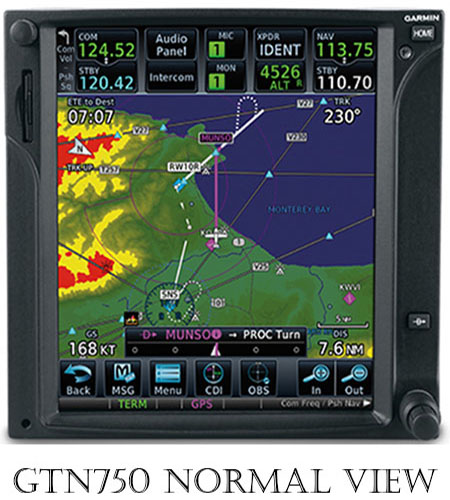
GTN750 Product Images
 |
||||||
Hover over any picture below to see a larger image above. |
||||||
 |
 |
 |
 |
 |
 |
 |